


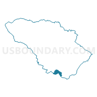
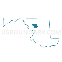
Howard Precinct 06-028, Howard County, Maryland
About
Outline

Summary
| Unique Area Identifier | 592596 |
| Name | Howard Precinct 06-028 |
| County | Howard County |
| State | Maryland |
| Area (square miles) | 2.34 |
| Land Area (square miles) | 2.01 |
| Water Area (square miles) | 0.33 |
| % of Land Area | 85.80 |
| % of Water Area | 14.20 |
| Latitude of the Internal Point | 39.13217120 |
| Longtitude of the Internal Point | -76.89531810 |
Maps

Graphs
Select a template below for downloading or customizing gragh for Howard Precinct 06-028, Howard County, Maryland


Neighbors
Neighoring Voting District (by Name) Neighboring Voting District on the Map
- Howard Precinct 05-006, Howard County, MD
- Howard Precinct 05-020, Howard County, MD
- Howard Precinct 06-024, Howard County, MD
- Howard Precinct 06-032, Howard County, MD
- Montgomery Precinct 05-018, Montgomery County, MD
- Prince George's Precinct 10-005, Prince George's County, MD
Top 10 Neighboring County Subdivision (by Population) Neighboring County Subdivision on the Map
- District 5, Montgomery County, MD (104,933)
- District 6, Savage, Howard County, MD (90,720)
- District 5, Clarksville, Howard County, MD (63,841)
- District 10, Laurel, Prince George's County, MD (58,017)
Top 10 Neighboring Place (by Population) Neighboring Place on the Map
- Scaggsville CDP, MD (24,333)
- Burtonsville CDP, MD (8,323)
- West Laurel CDP, MD (4,230)
- Fulton CDP, MD (2,049)
Top 10 Neighboring Unified School District (by Population) Neighboring Unified School District on the Map
- Montgomery County Public Schools, MD (971,777)
- Prince George's County Public Schools, MD (863,420)
- Howard County Public Schools, MD (287,085)
Top 10 Neighboring State Legislative District Lower Chamber (by Population) Neighboring State Legislative District Lower Chamber on the Map
- State Legislative District 13, MD (131,784)
- State Legislative District 21, MD (130,048)
- State Legislative District 14, MD (120,883)
Top 10 Neighboring State Legislative District Upper Chamber (by Population) Neighboring State Legislative District Upper Chamber on the Map
- State Senate District 13, MD (131,784)
- State Senate District 21, MD (130,048)
- State Senate District 14, MD (120,883)
Top 10 Neighboring 111th Congressional District (by Population) Neighboring 111th Congressional District on the Map
- Congressional District 5, MD (767,369)
- Congressional District 4, MD (714,316)
- Congressional District 7, MD (659,776)
Top 10 Neighboring Census Tract (by Population) Neighboring Census Tract on the Map
- Census Tract 6051.02, Howard County, MD (8,211)
- Census Tract 7014.10, Montgomery County, MD (7,568)
- Census Tract 6068.06, Howard County, MD (6,441)
- Census Tract 6069.06, Howard County, MD (5,615)
- Census Tract 8002.03, Prince George's County, MD (4,252)
- Census Tract 6068.05, Howard County, MD (4,145)
- Census Tract 8001.05, Prince George's County, MD (3,465)